RVCA - Flood Watch issued for Upper Watershed Lakes as Water Levels Continue to Rise
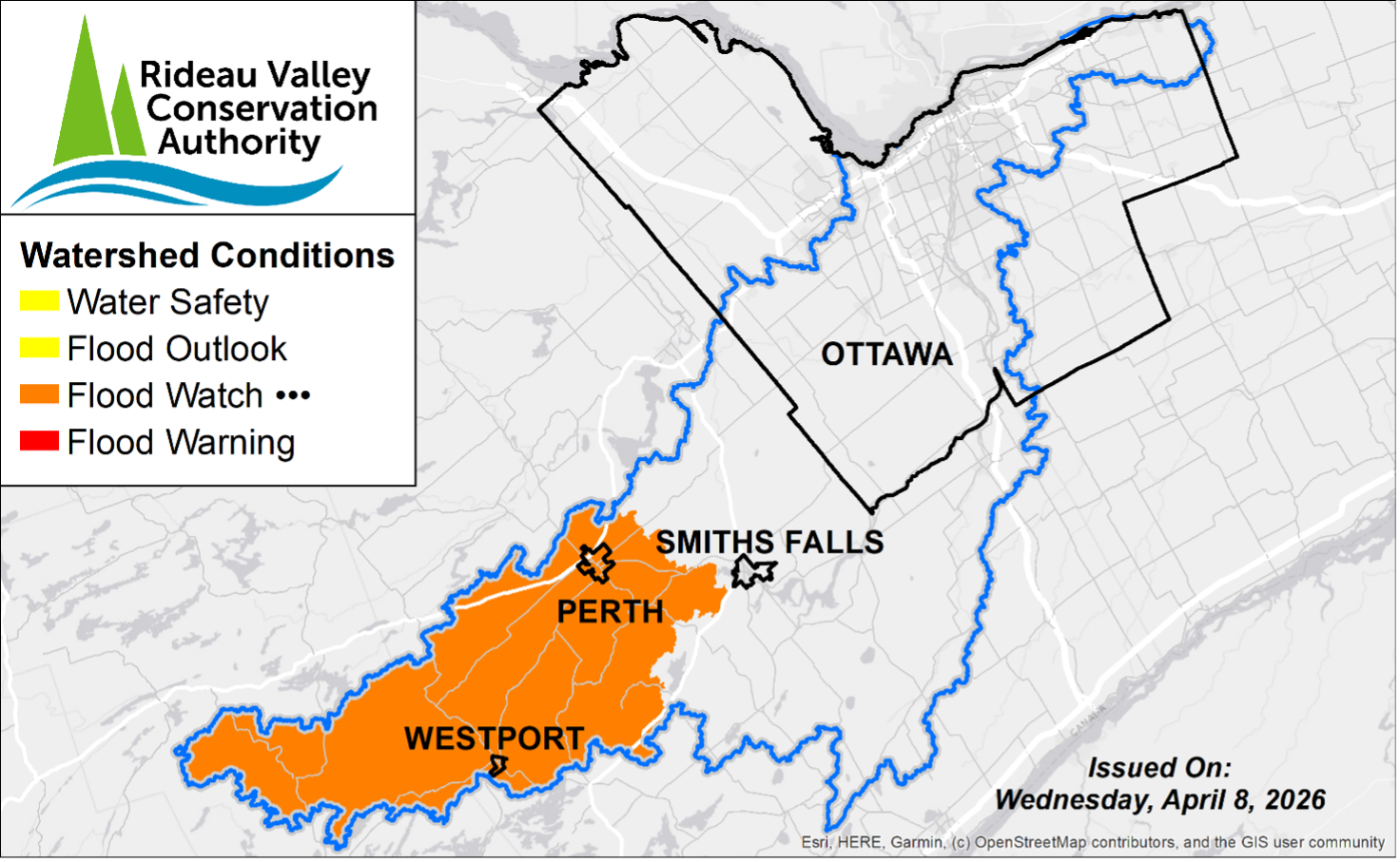
A Flood Watch has been issued for the Tay Valley and Rideau Lakes regions as water levels and flows remain high in the upper watershed lakes area. Reservoirs in this area have reduced capacity, which has increased the risk of localized flooding in low-lying regions.
Residents are strongly encouraged to remain vigilant, monitor local conditions, and take necessary steps to protect their properties. Please refer to the recommended actions and safety measures provided below.
MORE DETAILS:
Weather Forecast: Recent rainfall of 25–35 mm over the past week, combined with ongoing snowmelt, has resulted in elevated runoff and rising water levels across the Upper Watershed. A sustained warming trend over the next 10 days, with temperatures consistently above zero, is expected to continue snowmelt and runoff.An additional rainfall event of approximately 7–12 mm is forecast for April 9–10, which is expected to sustain rising water levels. Further precipitation is possible into mid-April; however, forecast confidence decreases with respect to timing and total accumulation.
Environmental Conditions: Water levels and flows across the Rideau Valley watershed remain elevated due to the ongoing spring freshet. Recent melt and rainfall have contributed to a rapid rise in water levels within the Upper Watershed lakes, with much of the available storage capacity now reduced. Rising water levels will increase the potential for flooding within the reservoir systems and downstream reaches, particularly in low-lying areas and locations historically susceptible to flooding.
Only remnant snowpack remains across the watershed. Additional rainfall and ongoing runoff are expected to further elevate water levels given the reduced capacity within these systems.
Risks: The upper watershed lakes are under a Flood Watch, based on the following factors:
- With reduced capacity remaining within the upper reservoirs, water levels may approach flooding onset within low-lying areas and locations historically susceptible to flooding.
Location-Specific Considerations:
Tay River Subwatershed – Bobs Lake & Christie Lake
Properties in the upper Tay River subwatershed may be impacted as water levels approach flooding onset over the coming days. In particular, residents in low-lying areas near Bobs Lake and Christie Lake that are historically prone to flooding should take necessary precautions to protect their property. Parks Canada staff are closely monitoring conditions and adjusting operations as required to manage water levels between the lakes.
Upper Rideau Subwatershed – Reservoir Lakes
Wolfe Lake, Upper Rideau Lake, and Big Rideau Lake levels are above average and are expected to increase. Significant flooding is not anticipated at this time, however nuisance flooding within low-lying areas is possible.
Action & Safety Recommendations: Residents in flood-prone areas are advised to closely monitor water levels and flows and take the necessary precautions to protect their property, such as:
- Ensuring sump pumps are clear, in good working condition, and have a backwater valve;
- Keeping a portable backup generator and pump easily accessible;
- Ensuring downspouts are clear and directing water at least 3 m away from the dwelling;
- Securing items that might float away as flows increase;
- Removing valuable items from basements or lower floors that could be subject to flooding;
- Keeping emergency phone numbers handy;
- Familiarizing yourself with your municipality’s Emergency Preparedness Plan.
Residents are reminded that a Water Safety Statement is in effect for the entire watershed until April 30th and advised to exercise caution when near rivers, streams, and other waterbodies due to the risks described above. Parents should inform their children of these dangers and provide appropriate supervision.
Duration: This Flood Watch is in effect until April 22 at 11:59 pm or until an update has been issued.
RVCA monitors water levels and weather forecasts as part of its Flood Forecasting and Warning Program. Updates will be provided as conditions change.
Contact Us
Municipal Office
217 Harper Road,
Perth, Ontario, K7H 3C6
Phone: 613-267-5353
Toll-Free: 1-800-810-0161
Email Us
Hours of Operation
Monday to Friday
8:30 a.m. to 4:00 p.m. except on Statutory Holidays.
Sign up to our newsfeed
Stay up to date on the municipality's activities, events, programs and operations by subscribing to our eNews


