
 Location
Set in the southwest corner of Lanark County due west of Perth, Tay Valley Township is comprised of several small communities joined by a shared heritage and a love for the rural lifestyle.
Located in eastern Ontario, Tay Valley Township covers 554 square kilometers. Ottawa is just over 80 kilometers to the northeast and Peterborough is 98 kilometers to the west. Kingston and the USA border are 70 kilometers to the south.
| Driving Directions |
|
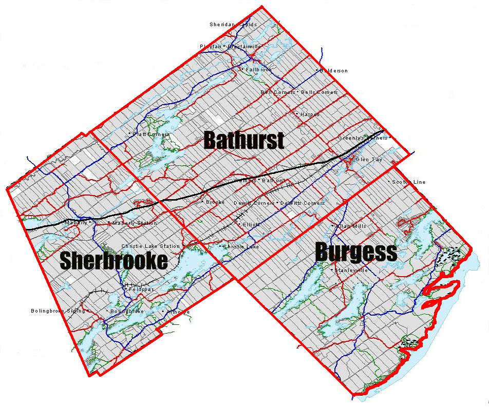
Tay Valley Township incorporates the rich history of three former townships, Bathurst, Burgess and South Sherbrooke, all of whom combined to make the Township we have today. |
| History and Historic Sites |
|
Whether you are a visitor or resident of the area, you will find it is a Welcome Change of Pace . |
Demographics
| Population | |||||||||||||||||||||||||||||||||||||||||||||||||||||||||||||||||||||||||||||||||||||||||
Source: Statistics Canada, 2011 Census of Population |
|||||||||||||||||||||||||||||||||||||||||||||||||||||||||||||||||||||||||||||||||||||||||
| Age Characteristics | |||||||||||||||||||||||||||||||||||||||||||||||||||||||||||||||||||||||||||||||||||||||||
Source: Statistics Canada, 2011 Census of Population |
|||||||||||||||||||||||||||||||||||||||||||||||||||||||||||||||||||||||||||||||||||||||||
| Age Distribution | |||||||||||||||||||||||||||||||||||||||||||||||||||||||||||||||||||||||||||||||||||||||||
Source: Statistics Canada, 2011 Census of Population |
|||||||||||||||||||||||||||||||||||||||||||||||||||||||||||||||||||||||||||||||||||||||||
| Marital Status | |||||||||||||||||||||||||||||||||||||||||||||||||||||||||||||||||||||||||||||||||||||||||
Source: Statistics Canada, 2011 Census of Population |
|||||||||||||||||||||||||||||||||||||||||||||||||||||||||||||||||||||||||||||||||||||||||
| Family Characteristics | |||||||||||||||||||||||||||||||||||||||||||||||||||||||||||||||||||||||||||||||||||||||||
Source: Statistics Canada, 2011 Census of Population |
|||||||||||||||||||||||||||||||||||||||||||||||||||||||||||||||||||||||||||||||||||||||||
| Language | |||||||||||||||||||||||||||||||||||||||||||||||||||||||||||||||||||||||||||||||||||||||||
Source: Statistics Canada, 2011 Census of Population |
|||||||||||||||||||||||||||||||||||||||||||||||||||||||||||||||||||||||||||||||||||||||||
| Household Characteristics | |||||||||||||||||||||||||||||||||||||||||||||||||||||||||||||||||||||||||||||||||||||||||
Source: 2014 Official Plan Background Study |
|||||||||||||||||||||||||||||||||||||||||||||||||||||||||||||||||||||||||||||||||||||||||
Workforce Profile
Major Employers of Tay Valley Township
Larger employers in the Township include OMYA, Lanark Lodge, Glen Tay School and Murphy’s Point Provincial Park, etc. Agriculture continues to play an important role in the township’s economy and rural landscape.
| Employment Breakdown - Tay Valley Township | ||||||||||||||||||||||||||||||||||||||||||||||||||||||||||||||||||||||||||||||||||||||||||||||||||||||||||||||||||||||||
Source: 2014 Official Plan Background Study |
||||||||||||||||||||||||||||||||||||||||||||||||||||||||||||||||||||||||||||||||||||||||||||||||||||||||||||||||||||||||
| Occupational Categories - Tay Valley Township | ||||||||||||||||||||||||||||||||||||||||||||||||||||||||||||||||||||||||||||||||||||||||||||||||||||||||||||||||||||||||
Source: City-Data, Statistics Canada, 2006 and 2011 Census of Population |
||||||||||||||||||||||||||||||||||||||||||||||||||||||||||||||||||||||||||||||||||||||||||||||||||||||||||||||||||||||||
| Industry Categories - Tay Valley Township | ||||||||||||||||||||||||||||||||||||||||||||||||||||||||||||||||||||||||||||||||||||||||||||||||||||||||||||||||||||||||
Source: City-Data, Statistics Canada, 2006 and 2011 Census of Population |
||||||||||||||||||||||||||||||||||||||||||||||||||||||||||||||||||||||||||||||||||||||||||||||||||||||||||||||||||||||||
| Labour Force Activity - Tay Valley Township | ||||||||||||||||||||||||||||||||||||||||||||||||||||||||||||||||||||||||||||||||||||||||||||||||||||||||||||||||||||||||
Source: City-Data, Statistics Canada, 2006 and 2011 Census of Population |
||||||||||||||||||||||||||||||||||||||||||||||||||||||||||||||||||||||||||||||||||||||||||||||||||||||||||||||||||||||||
| Lanark County Labor Statistics | ||||||||||||||||||||||||||||||||||||||||||||||||||||||||||||||||||||||||||||||||||||||||||||||||||||||||||||||||||||||||
Source: Statistics Canada, 2011 Census of Population. |
||||||||||||||||||||||||||||||||||||||||||||||||||||||||||||||||||||||||||||||||||||||||||||||||||||||||||||||||||||||||
| Occupation - Lanark County | ||||||||||||||||||||||||||||||||||||||||||||||||||||||||||||||||||||||||||||||||||||||||||||||||||||||||||||||||||||||||
Source: Statistics Canada, 2011 Census of Population |
||||||||||||||||||||||||||||||||||||||||||||||||||||||||||||||||||||||||||||||||||||||||||||||||||||||||||||||||||||||||
| Industry - Lanark County | ||||||||||||||||||||||||||||||||||||||||||||||||||||||||||||||||||||||||||||||||||||||||||||||||||||||||||||||||||||||||
Source: Statistics Canada, 2011 Census of Population |
||||||||||||||||||||||||||||||||||||||||||||||||||||||||||||||||||||||||||||||||||||||||||||||||||||||||||||||||||||||||
| Place of Work Status | ||||||||||||||||||||||||||||||||||||||||||||||||||||||||||||||||||||||||||||||||||||||||||||||||||||||||||||||||||||||||
Source: Statistics Canada, 2011 Census of Population |
||||||||||||||||||||||||||||||||||||||||||||||||||||||||||||||||||||||||||||||||||||||||||||||||||||||||||||||||||||||||
Economic Profile
| Growth | ||||||||||||||||||||||||||||||||||||||||||||||||||||||||||||||||||||||||||||||||||||||||||||||||||||||||||||||||
|
||||||||||||||||||||||||||||||||||||||||||||||||||||||||||||||||||||||||||||||||||||||||||||||||||||||||||||||||
| Income | ||||||||||||||||||||||||||||||||||||||||||||||||||||||||||||||||||||||||||||||||||||||||||||||||||||||||||||||||
Source: City-Data, Statistics Canada, 2006 and 2011 Census of Population
|
||||||||||||||||||||||||||||||||||||||||||||||||||||||||||||||||||||||||||||||||||||||||||||||||||||||||||||||||
Bibliography:
City Data. "Tay Valley Township." Statistics . Statistics from Census, 12 Oct. 2010. Web. 27 May 2014.
Statistics Canada. 2012. Tay Valley, Ontario (Code 3509015) and Lanark, Ontario (Code 3509) (table). Census Profile . 2011 Census. Statistics Canada Catalogue no. 98-316-XWE. Ottawa. Released October 24, 2012. (accessed June 2, 2014).
Statistics Canada. 2012. Tay Valley, Ontario (Code 3509015) and Ontario (Code 35) (table). Census Profile . 2011 Census. Statistics Canada Catalogue no. 98-316-XWE. Ottawa. Released October 24, 2012. (accessed June 2, 2014).