Accessible Trails
| Tay River Pathway |
|
The Tay River Pathway is suitable for walking, wheelchairs and walkers and includes several park benches for resting along its way. Parking and access to the trail is available a the Lanark County Administration Building at 99 Christie Lake Road, Perth. 613-267-4200 |
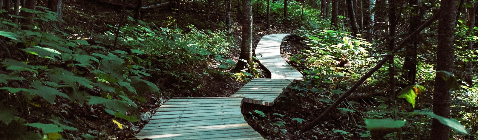
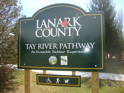 Located in Tay Valley on the western outskirts of Perth, you will find the Tay River Pathway starts just behind Lanark Lodge long term care facility adjacent to the Lanark County Administration Building. This 1.5 km loop trail provides a lovely accessible outdoor experience. The path passes the round garden, a red pine forest and leads to a waterfront lookout over the Tay River.
 Canoeing and Kayaking
| Hogg Bay - Big Rideau - Loon Lake Loop |
|
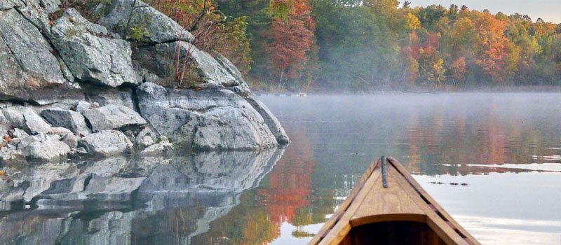
Murphys Point Provincial Park This park in Tay Valley Township offers lovely paddling opportunities, including the Hogg Bay-Big Rideau-Loon Lake Loop. Set out from the beach and head for the waters of Big Rideau Lake, following the left shoreline around the point into Noble Bay. Portage into tranquil Loon Lake, then to Hogg Bay, both of which have motorboat restrictions. There are picnic spots, beaches, trails, historic sites, amazing scenery and the accompanying wildlife. 613-267-5060 (Murphys Point). How to get there: Travel 6 kms south of Perth on County Road 1, to County Road 21. Turn towards Murphys Point Provincial Park and drive 12 kms. Launch Site: The main beach on Hogg Bay. Park fees may apply. The Paddle: Recommended direction for prevailing winds from the west: Paddle the narrow channel from Hogg Bay into Big Rideau Lake; keep to left shore around the point leading into Noble Bay. Paddle almost to the end of the bay, portage 100m into Loon Lake, then second portage of 100 m into Hogg Bay. Picnic at McParlan house (Hogg Bay), natural beach or point (Big Rideau), or Park Store (Loon Lake). Camping available at 14 boat-access campsites. |
| Long Lake |
|
How to get there: South from Perth on County Road 1, towards Rideau Ferry to County Road 21. Turn towards Murphys Point Provincial Park. Turn right at Long Lake Road. (See sign for Scout Camp) and travel 3 km. Launch Site: A small launch site can be seen on the left hand side of the road, onto the lake. The Paddle: South shore and islands more interesting. Several good places for swimming. Watch For: Creek into wetland at east end. Interesting lichen on rock walls. |
| Tay River - Glen Tay to Perth |
|
How to get there: Five km west of Perth on Highway 7 to traffic lights at Glen Tay. South over Rail-Road Tracks then left on Christie Lake Road, and right onto Glen Tay Road, to bridge over Tay River. Launch Site: NW corner of bridge across from stone mill. Cars park by stone wall/white house. Launch site is difficult for less able persons. Picnic table. Parking nearby. The Paddle: Shoot immediate rapids or walk your canoe down rapids. Paddle downriver to small dam at golf course. Portage (watch for flying golf balls) to point of land by red arched bridge. Picnic here at Stewart Park in Perth or cross the park to explore numerous restaurants and shops. Upon return, walk canoe up rapids to launch site. Watch for: Bountiful wildlife and wild flowers. |
| Pike Lake |
|
How to get there: From Highway 7, go into Perth (Wilson St., onto Gore St.) to County Road 10. Then west towards Westport about 15 km. Faded boat launch sign on left, 1 km past turnoff to Stanley Road. Launch Site: The dam in Grant's Creek. The Paddle: Up Grant's Creek into Pike Lake. Stay south (left), through islands and return. Good picnic sites on islands. Watch for: Small sandy beach in a mainland bay for swimming. Extensive wetland at east end of the lake. |
| Bennett Lake |
|
How to get there: From Perth, travel north on County Road 511 to Balderson, west on County Road 7 to Fallbrook, west on County Road 19 (Bennett Lake Road) 2 km to Ennis Road. Follow Ennis Road to Ennis Cottages (approx. 6km) Launch Site: At Ennis Cottages, a small launch fee is requested (approx. $10.00 per vessel). The paddle: Follow lake shore clockwise into Fall River and Fagan Lake. Or, follow the lakeshore counter clockwise into Fall River to dam and back. Watch for: Many small coves with various duck species and wild wetland flowers, rare black tern nests and other marshland birds. |
| Upper Tay to Christie Lake |
|
How to get there: Take Highway 7 west past Perth to Glen Tay Junction, turn left (south) on Glen Tay Road over Railroad Tracks to Christie Lake Road, then right (west) on Christie Lake Road for approx. 20 km to Hanna Road. Take Hanna Road almost to County Road 36. Launch Site: Small gravel launch site at the only place the River comes close to the road. Off load canoe and park on roadside lay-by. The Paddle: Upstream for 1 km, under bridge to head of rapids. Then go downstream into Christie Lake. The River is very beautiful, many turns, wetland bays, and wildlife. Watch for: Remnants of logging era on river bottom. Small Island in lake, directly out from mouth of the river, great for swimming and picnic. |
| Additional Information |
|
Lanark County Tourism offers a free brochure of all Canoe & Kayak Journeys. For additional information on lakes and launch points, see Tay Valley's Lakes and Rivers page. |
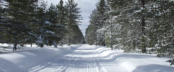
Cross Country Ski Trails
| Murphys Point Provincial Park/Tay Valley Ski Club |
| The Tay Valley Ski Club partners with Murphys Point Provincial Park to provide 28 km of cross-country ski trails, with 14 km groomed for classic, 7 km groomed for skating and 7 km ungroomed. A regular loppet is held and there are also special programs and events. Park at the main lot off Elm Grove Road or at the Lally Homestead; both are maintained in winter and have outhouses. Woodstoves can be found at the Lally Drive Shed and the winter chalet near the main parking lot. |
| Tay Havelock Trail |
|
This multi-use 22-kilometre stretch of trail (8.3 kms within Lanark County) follows an abandoned rail bed. There are multiple access points as this trail links with other trails for an extended journey through the scenic countryside. |
Cycling
Tay Valley Township is a great place to ride with many paths and roads to choose from. Explore the beauty of our area on two wheels.
The Perth Chamber of Commerce has developed a series of cycling routes. You can access these routes and the Lanark County Cycling map by visiting www.LanarkCountyTourism.com.
| Route 1 - Glen Tay |
| Distance: 15 km Details: Beginner - Short and flat Route Information |
| Route 2 - Murphys Point |
|
Distance: 42 km |
| Route 3 - Harper/Balderson |
| Distance: 26 km Details: Beginner - Short and flat Route Information |
| Route 4 - Maberley |
| Distance: 93 km Details: Difficult - Long with significant hilly terrain Route Information |
| Route 5 - Fallbrook |
| Distance: 25 km Details: Intermediate - Medium length with some rolling hills Route Information |
| Route 6 - Driver's Waltz |
|
Distance - 800 km |
Driving Routes
| Maple Driving Route |
|
This route of 120 km, starts and finishes in Perth. Drivers have the opportunity to discover the area that is Tay Valley and explore landmarks and communities founded by the early Scottish and Irish emigrants. Take a drive and discover some of our local history! Following the War of 1812, a group of Scottish emigrants took advantage of government incentives to leave the impoverished lowlands and start a new life in the British military settlements of Upper Canada. However, they maintained links to the old by naming communities and landmarks after familiar places back home, and using their skills to build substantial mills, fine homes, and tidy farms. Tay Valley became the cradle for much of this Scottish--and Irish--industriousness, much of it lovingly preserved under the careful stewardship of subsequent generations. For details on this historic driving route, look for the "Tay Valley" description on the following webpage entitled, "Historic Driving Routes". |
| Rideau Heritage Route |
| The Rideau Heritage Route is a meandering drive that enters Tay Valley to the south of the Narrows Lock Road and passes through the hamlet of Glen Tay and then continues east to Perth. Route Information |
| Trans Canada Trail |
|
This 105.7-kilometre route on Lanark County roads forms a connection between the Cataraqui Trail, the Tay Havelock Trail and the Ottawa Valley Recreational Trail (OVRT). The Trans Canada Trail is an 'on road' trail across Lanark County and enters Tay Valley from Perth, passes through the north part of Glen Tay, north up the Harper Road, east to Balderson, and then continues to Lanark, Almonte and Carleton Place. For more information, contact Lanark County at 613-267-4200. |
Equestrian Trails
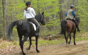
| Tay Havelock Trail |
|
This multi-use 22-kilometre stretch of trail (8.3 kms within Lanark County) follows an abandoned rail bed. There are multiple access points as this trail links with other trails for an extended journey through the scenic countryside. The Tay Havelock Trail runs along the old rail line from Glen Tay through Frontenac County. Parking and access south of Highway 7 at 18471 ON-7. For information, contact Lanark County at 613-267-4200. |
ORV and Snowmobile Trails
| Tay Havelock Trail |
|
Popular with ATV users and snowmobilers, this multi-use 22-kilometre stretch of trail (8.3 kms within Lanark County) follows an abandoned rail bed. There are multiple access points as this trail links with other trails for an extended journey through the scenic countryside. ATV and Snowmobile users must acquire the OTC Gold Pass from a vendor such as Carson's on Highway 7 in Perth. The Tay Havelock Trail runs along the old rail line from Glen Tay through Frontenac County. Parking and access south of Highway 7 at 18471 ON-7. For information, contact Lanark County at 613-267-4200. |
|
Ontario Federation of Snowmobile Clubs |
|
Discover the many trails in Tay Valley. |
Walking Trails
| Conboy Trail |
|
This beautiful walking trail is located on a 98 acre parcel of County Forest in Tay Valley Township. The rolling trail features numerous walking paths with a scenic mixed bush. Directions: Take Highway 7 turn south onto Cameron Side Road (12 kms west of Perth) and turn west onto Bathurst 5th Concession. The trail head parking lot is on the north side one km from the Cameron Side Road intersection. For information, contact Lanark County at 613-267-4200. |
| Murphys Point Provincial Park |
|
With more than 20 km of trails, you'll find scenic vistas, historic sites, abundant flora and fauna and Canadian Shield landscapes. There are varied levels of difficulty, multiple access points, parking lots and washroom facilities. Provincial Park fees may apply. The Park is located 20 km south of Perth at 2243 Elm Grove Road. 613-267-5060 |
| Rideau Trail |
|
Avid hikers have no shortage of natural and cultural features to explore on this remarkable all -season, 387-km trail between Ottawa and Kingston, which enters and exits Tay Valley to our south along the Big Rideau Lake and through Murphys Point Provincial Park. With a range of rugged Canadian Shield lands contrasted with quiet meadows and farmers' fields along stretches of roadway, this trail offers something for everyone. There are multiple access points. Map 1: Rideau North Shore: North Shore - Black Ance Point Road Map 2: Mica Mines: Black Ance Point Road - McLaren Point Parking at Conlon Farm or at the Crystal Palace in Perth, Lower Reach Park in Smiths Falls and Rosedale Hall in Montague (657 Rosedale Road South, Smiths Falls). For more information contact the Rideau Trails Association at 613-545-0823. |
| Silver Lake Provincial Park |
|
This easy, 0.5 km nature trail crosses a marsh by a boardwalk and leads to higher ground, where hikers can see the clear transition between wetland and upland forest, featuring rich flora and fauna. Silver Lake Provincial Park offers seasonal overnight camping, swimming, picnic areas, a playground, fishing, a boat launch, washroom facilities and parking. Provincial Park fees may apply. The park is located West of Perth on Highway 7, at 22726 ON-7, Maberly. 613-268-2000 |